A continent is one of several very large landmasses on Earth. They are generally identified by convention rather than any strict criteria, with seven regions commonly regarded as continents—they are (from largest in size to smallest): Asia, Africa, North America, South America, Antarctica, Europe, and Australia.

Asia
Asia is the world's largest and most populous continent, located primarily in the eastern and northern hemispheres. It covers 8.7% of the Earth's total surface area (or 30% of its land area) and with approximately 3.879 billion people, it hosts 60% of the world's current human population. During the 20th century Asia's population nearly quadrupled.
Asia is defined according to similar definitions presented by the Encyclopædia Britannica and the National Geographic Society as 4/5 of the landmass of Eurasia – with the western portion of the latter occupied by Europe – located to the east of the Suez Canal, east of the Ural Mountains and south of the Caucasus Mountains (or the Kuma-Manych Depression) and the Caspian and Black Seas. It is bounded on the east by the Pacific Ocean, on the south by the Indian Ocean and on the north by the Arctic Ocean. Given its size and diversity, Asia – a toponym dating back to classical antiquity – "is more a cultural concept" incorporating diverse regions and peoples than a homogeneous physical entity Asia differs very widely among and within its regions with regard to ethnic groups, cultures, environments, economics, historical ties and government systems.

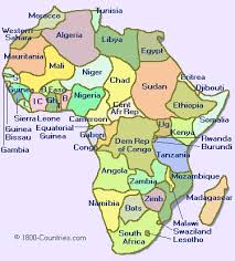
Africa is the world's second largest and second most populous continent, after Asia. At about 30.2 million km² (11.7 million sq mi) including adjacent islands, it covers 6% of the Earth's total surface area and 20.4% of the total land area. With 1.0 billion people (as of 2009, see table) in 61 territories, it accounts for about 14.72% of the world's human population.
The continent is surrounded by the Mediterranean Sea to the north, both the Suez Canal and the Red Sea along the Sinai Peninsula to the northeast, the Indian Ocean to the southeast, and the Atlantic Ocean to the west. The continent has 56 sovereign states, which includes Madagascar and various island groups, and two unrecognised countries.
Africa, particularly central Eastern Africa, is widely regarded within the scientific community to be the origin of humans and the Hominidae clade (great apes), as evidenced by the discovery of the earliest hominids and their ancestors, as well as later ones that have been dated to around seven million years ago – including Sahelanthropus tchadensis, Australopithecus africanus, A. afarensis, Homo erectus, H. habilis and H. ergaster – with the earliest Homo sapiens (modern human) found in Ethiopia being dated to circa 200,000 years ago.
Africa straddles the equator and encompasses numerous climate areas; it is the only continent to stretch from the northern temperate to southern temperate zones. The African expected economic growth rate is at about 5.0% for 2010 and 5.5% in 2011.
North America
North America (Spanish: América del Norte or Norteamérica; French: Amérique du Nord; Dutch: Noord-Amerika; Papiamento: Nort Amerika; Kalaallisut: Amerika Avannarleq) is a continent wholly within the Northern Hemisphere and almost wholly within the Western Hemisphere. It is also considered a northern subcontinent of the Americas. It is bordered to the north by the Arctic Ocean, to the east by the Atlantic Ocean, to the southeast by South America, and to the west and south by the Pacific Ocean.
North America covers an area of about 24,709,000 square kilometers (9,540,000 square miles), about 4.8% of the planet's surface or about 16.5% of its land area. As of July 2008, its population was estimated at nearly 529 million people. It is the third-largest continent in area, following Asia and Africa, and the fourth in population after Asia, Africa, and Europe.

South America
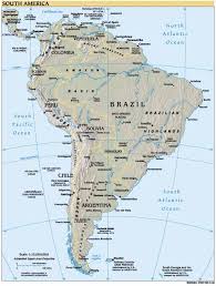
South America (Spanish: América del Sur, Sudamérica or Suramérica; Portuguese: América do Sul; Quechua and Aymara: Urin Awya Yala; Guarani: Ñembyamérika; Dutch: Zuid-Amerika; French: Amérique du Sud) is a continent situated in the Western Hemisphere, mostly in the Southern Hemisphere, with a relatively small portion in the Northern Hemisphere. The continent is also considered a subcontinent of the Americas. It is bordered on the west by the Pacific Ocean and on the north and east by the Atlantic Ocean; North America and the Caribbean Sea lie to the northwest. It includes twelve independent countries—Argentina, Bolivia, Brazil, Chile, Colombia, Ecuador, Guyana, Paraguay, Peru, Suriname, Uruguay, and Venezuela—and French Guiana, which is an overseas region of France. The South American countries that border the Caribbean Sea—Colombia, Venezuela, Guyana, Suriname, and French Guiana—are also known as Caribbean South America.
South America has an area of 17,840,000 square kilometers (6,890,000 sq mi). Its population as of 2005 has been estimated at more than 371,090,000. South America ranks fourth in area (after Asia, Africa, and North America) and fifth in population (after Asia, Africa, Europe, and North America). The word America was coined in 1507 by cartographers Martin Waldseemüller and Matthias Ringmann, after Amerigo Vespucci, who was the first European to suggest that the lands newly discovered by Europeans were not India, but a New World unknown to Europeans.
Antarctica
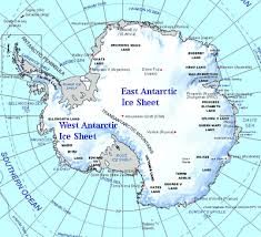
Antarcticais Earth's southernmost continent, encapsulating the South Pole. It is situated in the Antarctic region of the Southern Hemisphere, almost entirely south of the Antarctic Circle, and is surrounded by the Southern Ocean. At 14.0 million km2 (5.4 million sq mi), it is the fifth-largest continent in area after Asia, Africa, North America, and South America. For comparison, Antarctica is nearly twice the size of Australia. About 98% of Antarctica is covered by ice that averages at least 1.6 kilometres (0.99 mi) in thickness.
Antarctica, on average, is the coldest, driest, and windiest continent, and has the highest average elevation of all the continents. Antarctica is considered a desert, with annual precipitation of only 200 mm (8 inches) along the coast and far less inland.The temperature in Antarctica has reached −89 °C (−129 °F). There are no permanent human residents, but anywhere from 1,000 to 5,000 people reside throughout the year at the research stations scattered across the continent. Only cold-adapted organisms survive there, including many types of algae, animals (for example mites, nematodes, penguins, seals and tardigrades), bacteria, fungi, plants, and protista. Vegetation where it occurs is tundra.
Although myths and speculation about a Terra Australis ("Southern Land") date back to antiquity, the first confirmed sighting of the continent is commonly accepted to have occurred in 1820 by the Russian expedition of Fabian Gottlieb von Bellingshausen and Mikhail Lazarev. The continent, however, remained largely neglected for the rest of the 19th century because of its hostile environment, lack of resources, and isolation. The Antarctic Treaty was signed in 1959 by 12 countries; to date, 47 countries have signed the treaty. The treaty prohibits military activities and mineral mining, prohibits nuclear explosions and nuclear power, supports scientific research, and protects the continent's ecozone. Ongoing experiments are conducted by more than 4,000 scientists of multiple nationalities.
Europe
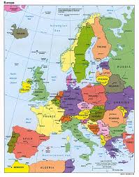
Europe is, by convention, one of the world's seven continents. Comprising the westernmost peninsula of Eurasia, Europe is generally 'divided' from Asia to its east by the watershed divides of the Ural and Caucasus Mountains, the Ural River, the Caspian and Black Seas, and the waterways connecting the Black and Aegean Seas. Europe is bordered by the Arctic Ocean and other bodies of water to the north, the Atlantic Ocean to the west, the Mediterranean Sea to the south, and the Black Sea and connected waterways to the southeast. Yet the borders of Europe—a concept dating back to classical antiquity—are somewhat arbitrary, as the primarily physiographic term "continent" can incorporate cultural and political elements.
Europe is the world's second-smallest continent by surface area, covering about 10,180,000 square kilometres (3,930,000 sq mi) or 2% of the Earth's surface and about 6.8% of its land area. Of Europe's approximately 50 states, Russia is the largest by both area and population (although the country has territory in both Europe and Asia), while the Vatican City is the smallest. Europe is the third-most populous continent after Asia and Africa, with a population of 733 million or about 11% of the world's population.
Europe, in particular Ancient Greece, is the birthplace of Western culture. It played a predominant role in global affairs from the 16th century onwards, especially after the beginning of colonialism. Between the 16th and 20th centuries, European nations controlled at various times the Americas, most of Africa, Oceania, and large portions of Asia. Both World Wars were largely focused upon Europe, greatly contributing to a decline in Western European dominance in world affairs by the mid-20th century as the United States and Soviet Union took prominence. During the Cold War, Europe was divided along the Iron Curtain between NATO in the west and the Warsaw Pact in the east. European integration led to the formation of the Council of Europe and the European Union in Western Europe, both of which have been expanding eastward since the fall of the Soviet Union in 1991.
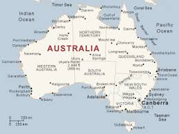
Australia
Australia is the world's smallest continent, comprising the mainland of Australia and proximate islands including Tasmania, New Guinea, the Aru Islands and Raja Ampat Islands. Australia and these nearby islands, all part of the same geological landmass, are separated by seas overlying the continental shelf — the Arafura Sea and Torres Strait between Australia and New Guinea, and Bass Strait between mainland Australia and Tasmania.
When sea levels were lower during the Pleistocene ice age, including the last glacial maximum about 18,000 BC, the lands formed a single, continuous landmass. During the past ten thousand years, rising sea levels overflowed the lowlands and separated the continent into today's low-lying arid to semi-arid mainland and the two mountainous islands of New Guinea and Tasmania.
Geologically, the continent extends to the edge of the continental shelf, so the now-separate lands can still be considered a continent. Due to the spread of flora and fauna across the single Pleistocene landmass the separate lands have a related biota.
New Zealand is not on the same continental shelf and so is not part of the continent of Australia but is part of the submerged continent Zealandia. Zealandia and Australia together are part of the wider region known as Oceania or Australasia. Australia is sometimes known in technical contexts by the names Sahul, Australinea and Meganesia.
Asia
Asia is the world's largest and most populous continent, located primarily in the eastern and northern hemispheres. It covers 8.7% of the Earth's total surface area (or 30% of its land area) and with approximately 3.879 billion people, it hosts 60% of the world's current human population. During the 20th century Asia's population nearly quadrupled.
Asia is defined according to similar definitions presented by the Encyclopædia Britannica and the National Geographic Society as 4/5 of the landmass of Eurasia – with the western portion of the latter occupied by Europe – located to the east of the Suez Canal, east of the Ural Mountains and south of the Caucasus Mountains (or the Kuma-Manych Depression) and the Caspian and Black Seas. It is bounded on the east by the Pacific Ocean, on the south by the Indian Ocean and on the north by the Arctic Ocean. Given its size and diversity, Asia – a toponym dating back to classical antiquity – "is more a cultural concept" incorporating diverse regions and peoples than a homogeneous physical entity Asia differs very widely among and within its regions with regard to ethnic groups, cultures, environments, economics, historical ties and government systems.
Africa
Africa is the world's second largest and second most populous continent, after Asia. At about 30.2 million km² (11.7 million sq mi) including adjacent islands, it covers 6% of the Earth's total surface area and 20.4% of the total land area. With 1.0 billion people (as of 2009, see table) in 61 territories, it accounts for about 14.72% of the world's human population.
The continent is surrounded by the Mediterranean Sea to the north, both the Suez Canal and the Red Sea along the Sinai Peninsula to the northeast, the Indian Ocean to the southeast, and the Atlantic Ocean to the west. The continent has 56 sovereign states, which includes Madagascar and various island groups, and two unrecognised countries.
Africa, particularly central Eastern Africa, is widely regarded within the scientific community to be the origin of humans and the Hominidae clade (great apes), as evidenced by the discovery of the earliest hominids and their ancestors, as well as later ones that have been dated to around seven million years ago – including Sahelanthropus tchadensis, Australopithecus africanus, A. afarensis, Homo erectus, H. habilis and H. ergaster – with the earliest Homo sapiens (modern human) found in Ethiopia being dated to circa 200,000 years ago.
Africa straddles the equator and encompasses numerous climate areas; it is the only continent to stretch from the northern temperate to southern temperate zones. The African expected economic growth rate is at about 5.0% for 2010 and 5.5% in 2011.
North America
North America (Spanish: América del Norte or Norteamérica; French: Amérique du Nord; Dutch: Noord-Amerika; Papiamento: Nort Amerika; Kalaallisut: Amerika Avannarleq) is a continent wholly within the Northern Hemisphere and almost wholly within the Western Hemisphere. It is also considered a northern subcontinent of the Americas. It is bordered to the north by the Arctic Ocean, to the east by the Atlantic Ocean, to the southeast by South America, and to the west and south by the Pacific Ocean.
North America covers an area of about 24,709,000 square kilometers (9,540,000 square miles), about 4.8% of the planet's surface or about 16.5% of its land area. As of July 2008, its population was estimated at nearly 529 million people. It is the third-largest continent in area, following Asia and Africa, and the fourth in population after Asia, Africa, and Europe.
South America
South America (Spanish: América del Sur, Sudamérica or Suramérica; Portuguese: América do Sul; Quechua and Aymara: Urin Awya Yala; Guarani: Ñembyamérika; Dutch: Zuid-Amerika; French: Amérique du Sud) is a continent situated in the Western Hemisphere, mostly in the Southern Hemisphere, with a relatively small portion in the Northern Hemisphere. The continent is also considered a subcontinent of the Americas. It is bordered on the west by the Pacific Ocean and on the north and east by the Atlantic Ocean; North America and the Caribbean Sea lie to the northwest. It includes twelve independent countries—Argentina, Bolivia, Brazil, Chile, Colombia, Ecuador, Guyana, Paraguay, Peru, Suriname, Uruguay, and Venezuela—and French Guiana, which is an overseas region of France. The South American countries that border the Caribbean Sea—Colombia, Venezuela, Guyana, Suriname, and French Guiana—are also known as Caribbean South America.
South America has an area of 17,840,000 square kilometers (6,890,000 sq mi). Its population as of 2005 has been estimated at more than 371,090,000. South America ranks fourth in area (after Asia, Africa, and North America) and fifth in population (after Asia, Africa, Europe, and North America). The word America was coined in 1507 by cartographers Martin Waldseemüller and Matthias Ringmann, after Amerigo Vespucci, who was the first European to suggest that the lands newly discovered by Europeans were not India, but a New World unknown to Europeans.
Antarctica
Antarcticais Earth's southernmost continent, encapsulating the South Pole. It is situated in the Antarctic region of the Southern Hemisphere, almost entirely south of the Antarctic Circle, and is surrounded by the Southern Ocean. At 14.0 million km2 (5.4 million sq mi), it is the fifth-largest continent in area after Asia, Africa, North America, and South America. For comparison, Antarctica is nearly twice the size of Australia. About 98% of Antarctica is covered by ice that averages at least 1.6 kilometres (0.99 mi) in thickness.
Antarctica, on average, is the coldest, driest, and windiest continent, and has the highest average elevation of all the continents. Antarctica is considered a desert, with annual precipitation of only 200 mm (8 inches) along the coast and far less inland.The temperature in Antarctica has reached −89 °C (−129 °F). There are no permanent human residents, but anywhere from 1,000 to 5,000 people reside throughout the year at the research stations scattered across the continent. Only cold-adapted organisms survive there, including many types of algae, animals (for example mites, nematodes, penguins, seals and tardigrades), bacteria, fungi, plants, and protista. Vegetation where it occurs is tundra.
Although myths and speculation about a Terra Australis ("Southern Land") date back to antiquity, the first confirmed sighting of the continent is commonly accepted to have occurred in 1820 by the Russian expedition of Fabian Gottlieb von Bellingshausen and Mikhail Lazarev. The continent, however, remained largely neglected for the rest of the 19th century because of its hostile environment, lack of resources, and isolation. The Antarctic Treaty was signed in 1959 by 12 countries; to date, 47 countries have signed the treaty. The treaty prohibits military activities and mineral mining, prohibits nuclear explosions and nuclear power, supports scientific research, and protects the continent's ecozone. Ongoing experiments are conducted by more than 4,000 scientists of multiple nationalities.
Europe
Europe is, by convention, one of the world's seven continents. Comprising the westernmost peninsula of Eurasia, Europe is generally 'divided' from Asia to its east by the watershed divides of the Ural and Caucasus Mountains, the Ural River, the Caspian and Black Seas, and the waterways connecting the Black and Aegean Seas. Europe is bordered by the Arctic Ocean and other bodies of water to the north, the Atlantic Ocean to the west, the Mediterranean Sea to the south, and the Black Sea and connected waterways to the southeast. Yet the borders of Europe—a concept dating back to classical antiquity—are somewhat arbitrary, as the primarily physiographic term "continent" can incorporate cultural and political elements.
Europe is the world's second-smallest continent by surface area, covering about 10,180,000 square kilometres (3,930,000 sq mi) or 2% of the Earth's surface and about 6.8% of its land area. Of Europe's approximately 50 states, Russia is the largest by both area and population (although the country has territory in both Europe and Asia), while the Vatican City is the smallest. Europe is the third-most populous continent after Asia and Africa, with a population of 733 million or about 11% of the world's population.
Europe, in particular Ancient Greece, is the birthplace of Western culture. It played a predominant role in global affairs from the 16th century onwards, especially after the beginning of colonialism. Between the 16th and 20th centuries, European nations controlled at various times the Americas, most of Africa, Oceania, and large portions of Asia. Both World Wars were largely focused upon Europe, greatly contributing to a decline in Western European dominance in world affairs by the mid-20th century as the United States and Soviet Union took prominence. During the Cold War, Europe was divided along the Iron Curtain between NATO in the west and the Warsaw Pact in the east. European integration led to the formation of the Council of Europe and the European Union in Western Europe, both of which have been expanding eastward since the fall of the Soviet Union in 1991.
Australia
Australia is the world's smallest continent, comprising the mainland of Australia and proximate islands including Tasmania, New Guinea, the Aru Islands and Raja Ampat Islands. Australia and these nearby islands, all part of the same geological landmass, are separated by seas overlying the continental shelf — the Arafura Sea and Torres Strait between Australia and New Guinea, and Bass Strait between mainland Australia and Tasmania.
When sea levels were lower during the Pleistocene ice age, including the last glacial maximum about 18,000 BC, the lands formed a single, continuous landmass. During the past ten thousand years, rising sea levels overflowed the lowlands and separated the continent into today's low-lying arid to semi-arid mainland and the two mountainous islands of New Guinea and Tasmania.
Geologically, the continent extends to the edge of the continental shelf, so the now-separate lands can still be considered a continent. Due to the spread of flora and fauna across the single Pleistocene landmass the separate lands have a related biota.
New Zealand is not on the same continental shelf and so is not part of the continent of Australia but is part of the submerged continent Zealandia. Zealandia and Australia together are part of the wider region known as Oceania or Australasia. Australia is sometimes known in technical contexts by the names Sahul, Australinea and Meganesia.
No comments:
Post a Comment